Once a jolly swagman camped by a Billabong
Under the shade of a Coolabah tree
And he sang as he watched and waited till his billy boiled
Who'll come a-waltzing Matilda with me?

Friday, January 27, 2006

West Coast Wilderness

(karen)
A big shout out to our devoted fans! Cheers for all the comments you've left for us. Sorry for being incommunicado as of late, we just completed a fantastic 10-day guided trip down the west coast of the South Island with the Hiking New Zealand tour company. I'm convinced that the New Zealand west coast is one of the most spectacular pieces of land anywhere on Earth. You really can't miss. It's damn near impossible to look around and not find something that looks like a postcard. The yang to scenic yin has got to be the sandflies, however. They are slow, stupid, and terribly easy to kill, but what they lack in quality they make up for in quantity. My feet look like I've got chicken pox!

There were 8 of us on the tour, plus our kiwi guide Fiona. Our fellow travelers were Tam from Brisbane (AUS) and Simon from Perth (AUS), Priska from Switzerland, Ulf from Sweden, and Florian from Germany. We got along very well and had a great experience tramping through the bush. I've posted a few pictures here, but the bulk of the photos are on the flickr website in the West Coast Wilderness Folder.

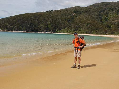
Gordon's Pass Backpack
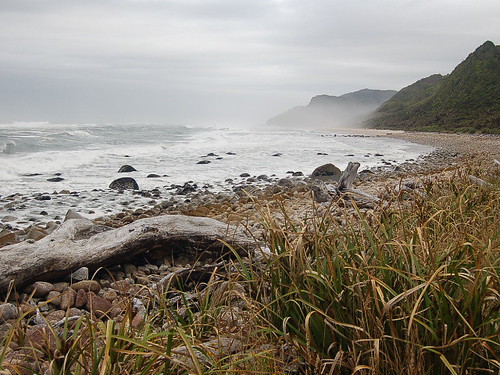
Our first overnight trip was in the Kahurangi National Park, which is actually the same park where the Heaphy track is loacted. We had a nice warm up hike to our campsite for the evening which was a natural overhanging rock shelter.

SSC_0259

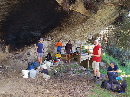
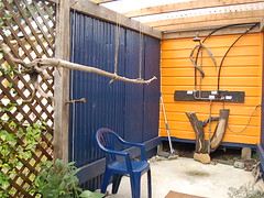
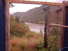
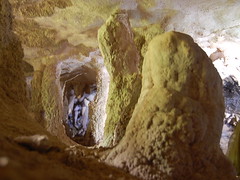
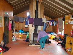
Before dinner we explored the surrounding area which has numerous deep sink holes from areas where the limestone caves that run throughout the region have collapsed. Overnight the weather turned cloudy and by morning a light rain was falling. We put on our rain gear and headed out for the summit of Gordon's Pyramid, above bushline. We hiked through the Tablelands which is a flat area of tussock surrounded by ridges, created by glaciers long ago. Once above bushline the rain worsened and the wind really began to howl along the ridges. I was happy to get off the ridges because I was nearly blown away at times! I was soaked through and through (as were most of our party) but somehow Steve managed to stay mostly dry. We stayed that evening in a cute little bach (holiday house) where we got to take turns in the best shower in New Zealand: an outdoor wood heated shower looking out on a picturesque river. I just wish I had more than a bandana to dry off with!

SSC_0262 SSC_0264


Inland Pack Track
We headed down the coast a bit for our next trip on the Inland Pack Track, which follows a path through river canyon areas. There was some concern if it was walkable due to the massive amounts of rain the day before, but luckily though the water level was higher than usual it was still safe. We squished our way through lots of mud at first, but soon found ourselves at the river. We followed the water downstream, crossing frequently. Most of the crossings were only up to the mid calf, but a few times we had to do buddy support crossings of four people with interlocked arms.

SSC_0277

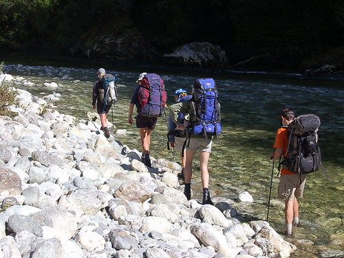
It seemed like we kept getting a little deeper with every crossing, but then we hit the grandaddy on (aptly named) Dilema Creek. The water was too deep to ford so Fiona taught us how to do a pack swim...which is pretty much exactly like it sounds. Everyone stripped down to the minimal amount of decent clothing and then one by one we walked out into the water, rolled onto our backs and kicked our way to the other side. Thank goodness for plastic garbage bags to keep my clothes and sleeping bag dry! It was a fantastic experience and I'm really glad to have done it. It took a long time for me to warm up after being in the river, but some hot chocolate and a long sit by the campfire worked their magic in the end.

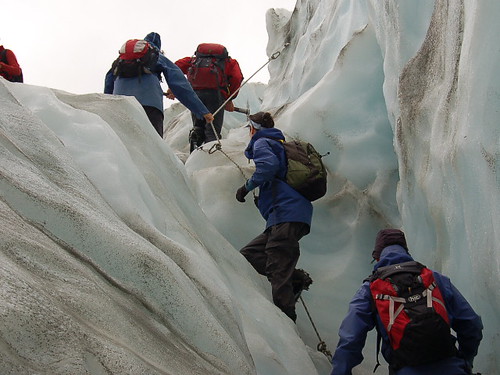
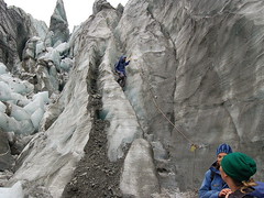
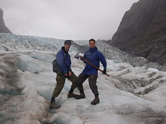
Franz Joseph Glacier Walk
On day 5 we had a breif respite from backpacking and most of us took the optional guided glacier walk on the Franz Joseph Glacier. The Franz Joseph and Fox Galciers are unique because they descend into temperate rain forest near the ocean. This is because they receive vast amounts of snow fall and push through very narrow valleys which cause them to flow quickly. Unlike the glacier walk I've done in Alaska which was fairly flat and smooth, this glacier was filled with huge jagged ice formations into which the guides continually are cutting stair paths. Crampons were a must. If you squint your eyes it seems like you're climbing Mt. Everest!

SSC_0289
SSC_0294 SSC_0293

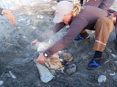
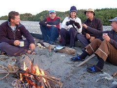
That evening we had a traditonal hangi feast on the beach, which is similar to the Hawaiian luau. We built a fire in the sand and heated several large stones in the center. We put little packets of veggies, lamb and chicken in the center, covered it with wet towels and then again with sand. Two hours later we had a fantastic feast around the campfire. Sooo close to heaven.

SSC_0297 SSC_0298


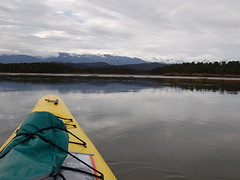
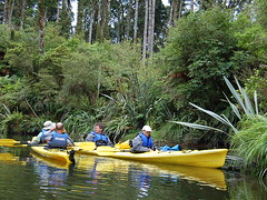
Kayaking Okarito Lagoon
We spent another day exercising our top halves by kayaking through the Okarito lagoon which is famous for its variety of bird life.

SSC_0299 SSC_0302


Welcome Flat Backpack
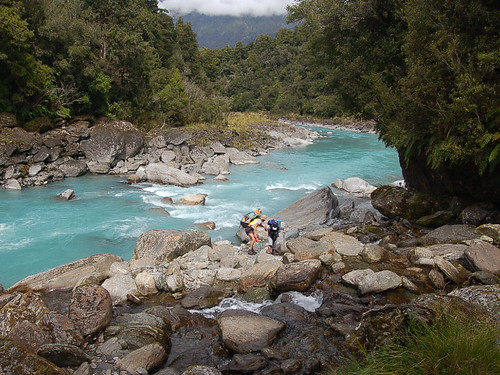
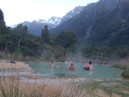
Our final backpacking trip was two nights at the Welcome Flat Hut. We followed a glacial river through a glacially carved valley, surrounded by the ranges of the Southern Alps. It was breathtaking to be in temperate rainforests next to a baby-blue river, surrounded by snow capped peaks.

SSC_0311

A perk of the Welcome Flat were the natural hot springs that had formed perfect soaking pools. It felt fantastic to sit in the hot water after a long day of hiking.

SSC_0317

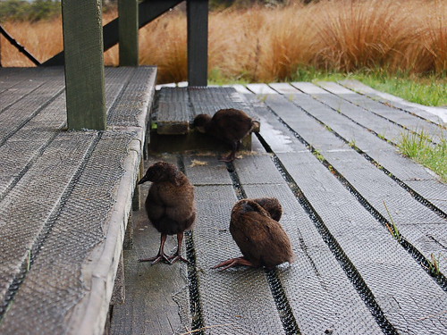
We were lucky to see the kea, or New Zealand mountain parrot, while at our hut. These beautiful birds are apparently some cheeky pranksters but we just watched them flair their green and orange wings as they swooped between the tree tops.

Queenstown
The trip is over now but many of us are still hanging out in Queenstown for a few days before we go our separate ways. Next trip is to the Milford Track so hopefully in another week we'll have a new batch of stories to share.

Monday, January 16, 2006

Heaps of Heaphy

(steve)
We just got back from completing the Heaphy Track, an 84 km walk through the hills to the wild, Tasman sea on the west coast of the North Island. The trip took 5 days with 4 nights in the fabulous DOC hut system (seen in a previous photo). This time we left the sleeping pads and water filter behind to lighten the packs. The trip started off with a medium-long bus ride through the hills that included two creek fords (in the bus!) before dumping us out. Once there we found out that there wasn't any treated water. Oops. Oh well, all the locals drink the water and come out all right. We took the chance that the rain water supply at the huts was good enough (so far no nasty trips to the toilet).

The trail took us through a variety of climates from mountainous to tussock to tropical to coastal palms in a relatively short span. The first night we had our initiation with a local bird called a weka. About the size of a chicken, these crafty birds (generally non-flying) walk around and steal anything that they can, especially brightly colored objects common to most backpacks. We had a family of 5 that lived under the hut check out our stuff within the first 10 minutes of our arrival. That first night we heard the gentle screech of a Kiwi (the bird this time) at about 2 am. The hut warden said that it took him six months to actually see the bird, so we didn't have high hopes.

SSC_0122

The next three days were spent walking through the bush (that still sounds dirty) looking out over spectacular views at the surrounding hills, headed towards the coast. The bedrock of the region is weathered limestone so we even found time to do some mini-cave explorations along the track. And what cave would be complete without cave wetas? One resource not lacking on the west coast of South Island is water. There are creeks, streams, and rivers everywhere (most were brown from the tannins in the leaves, but looked exactly like rivers of beer!). Funny thing about lots of creeks with no visible snow or lakes is that is comes from rain. Days 2 and 3 allowed us to field test our rain gear. Karen found out her jacket is water "resistant" as opposed to "proof." Makes all the difference after a 6 hour dousing. At least the huts are equiped with stoves to warm up and dry out. I got to make my first coal fire that night (with a little help from some camp fuel). Along the way we met a nice Swiss couple that ended up walking with us for almost the rest of the hike.

SSC_0120 SSC_0124

The most stunning part of the walk was the last day along the Tasman Sea. We left the hut (situated on a little hill overlooking the ocean) and continued along the beach the entire day. The Tasman Sea is absolutely amazing and very different from the ocean seen in previous photos, more grey and less inviting. The land was much more rugged (similar to the background in King Kong). The sound of the surf can be heard a half mile from shore. There were continual lines of large breakers that were mesmerizing. We finished the walk and took a little bus to Karamea to clean up. After 5 days the non-rain shower felt pretty good.

SSC_0141


We spent the rest of the day in Karamea (population 650) resting. The biggest drama came when I left our nice new camera on the bus (really just a mini-van). After realizing this I frantically tried calling the bus company for the rest of the night. My only response came from the hotel desk manager who said, "it'll turn up." Not encouraging. Salvation came when the very same bus driver showed up the next morning to take us on the next leg. A short stop in the bus depot and I was saved. We were the only passengers on the bus that day. Moral of story: I'm not allowed to carry the camera any more.

In the end, the Heaphy was a much more "camping" type of hike that showed this country is full of great sites and plenty to see. We are continually amazed at the variety of scenery and can't wait to keep moving to see what is next.

(The full range of photos are on the flickr website in the Heaphy Track folder. Just click on one of the photos to access the website. Cheers!)

Wednesday, January 11, 2006

Abel Tasman National Park

(karen)
Thank you everyone for your comments, we love getting to read them to see how you are doing. And for those concerned about my knee, it thankfully hasn't been a problem yet even after a 3-day backpacking trip in Abel Tasman National Park. Speaking of which, you all are in for a treat because we finally found an internet cafe that let us upload our pictures. I selected the highlights (because there are a few hundred so far!) and you can access them by clicking on the photo below. On the Flickr website you'll be able to see the folders I setup, which are called "Auckland", "To South Island", and "Abel Tasman".

Tramping on the beach

The Abel Tasman park is a beautiful corner of the world that looks like it is straight out of the 100% Pure New Zealand advertising campaign. It's in an area called the Gold Coast that which seems almost tropical because of the large palm-like silver ferns, pure gold sand and turquoise waters. It's a popular kayak spot but we decided to do a back packing trip instead. The path is pretty flat and gentle as it follows along the beaches and through the bush. One of the most interesting parts about this hike was the tidal influence. In a couple of spots we had to walk during low tide as the path went through sandy, muddy tidal flats. It was really fascinating to just sit and watch the tide come in and watch it fill up an entire shallow lagoon. At night we stayed in cabins which sounds like a good idea, and it is, but oh my god do people snore down undah'.

We spent a day recovering and stocking back up for our next trip on the Heaphy Track, a 5-day hike in a similar area. I'm actually writting this entry at 6:00 am while waiting for the bus to come pick us up! Surprisingly the station wasn't busy, I guess the other hostel goers are still passed out from the previous evening.


(steve)

Hello everyone. Here's my two cents. Everything you've heard about New Zealand being filled with great people is true. Every landscape you saw in Lord of the Rings is not staged (entirely). We've been lucky to see and experience both in a short while. Between having strangers ask us how the holiday is going while shopping in the supermarket to seeing some of the coastline on our first tramp (in the pictures), we haven't been disappointed. More from me when we get back from the next hike (got to catch a bus!). Hope everyone is well.

Friday, January 06, 2006

South Island, Ho!

(karen)
Sorry about the brevity of my last post. I realized I had a few seconds before my time ran out on the computer terminal and I barely managed to upload what I had written! So now, on with the rest of the story.

(Jan 2) In our second day in Aukland we decided to take a ferry over to the small volcanic island called Rangitoto. The volcano last erupted 600 years ago, and though it has since been reforested there are still sharp, black lava fields everywhere. We climbed to the summit and had a spectacular view of the Auckland harbor and surrounding areas. We even got to climb through an old lava tunnel!

(Jan 3) The next day we took a 12-hour train ride from Auckland to Wellington. We went straight through the heart of Hobbiton, and I think we might have seen glimpses of Weathertop and Rohan. No orcs yet. We stopped for lunch in Tongariro National Park which is near the base of Mt. Ruapeha, another very large volcano. This whole island is swarming with volcanos! You can see cinder cones dotting the landscape for miles. We arrived in Wellington that evening to gale force winds, gusting up to 160 km/hr. The receptionist at the hostel said that it was the strongest winds he'd seen in the two years he'd live here.

(Jan 4) Still heading for our destination to the South Island, we took a 3-hour ferry from Wellington across Cook Straight into Picton. We were amazed at how lovely the Queen Charlotte Sound is as we navigated through the maze of cliffs and forest to the harbour. Picton is a beautiful, quaint town that is nestled in the green hills overlooking the water. We haven't been able to upload our photos yet, but rest assured I took about 100 in the Sound.

(Jan 5) We spent the day kayaking in the Queen Charlotte Sound. We lucked out with good weather in the beginning and got to see some of the native bush up close, including colonies of spotted shags (that's a bird you dirty minded people). It rained in the evening, but as always with this country it blew through quickly and it was a pleasant, starry night. We keep trying to find the Southern Cross but it's so hard to tell.

Today we are heading over to the Nelson region to go tramping in Abel Tasman Park. I have a slight concern with my knee, which has inexplicably swelled in an area where I fell on it a month ago playing disc. We're keeping our eye on it to make sure it doesn't get any worse. Other than that we are having a lovely time and think New Zealand is one of the jewels of the world. Where else can you be surrounded by subtropical ferns, and see penguins swimming in the water?

Monday, January 02, 2006

It's summer!

(karen)
Well kids, we made it to our destination with only minor drama at the airport. I won't go into it but let's just say that it's a little creepy to be sitting on a place at the gate when all the power has been shut off. It's dark. But before long we flew 5 hours to Honolulu, switched planes and continued for another 9 hours to Auckland, New Zealand. Did you know you can see sheep from the airplane? It's true. We made it through agricultural inspection without incidence despite the rigorous inspection for our tent behind closed doors. We spent most of the day wandering around the streets of downtown, which were eerily deserted due to the New Year's holiday. We spent some time exploring th Auckland Museum which is perched on an old caldera in a lovely park called the Auckland Domain, checking out the largegst collection of pacific islander artifacts in the world.