Once a jolly swagman camped by a Billabong
Under the shade of a Coolabah tree
And he sang as he watched and waited till his billy boiled
Who'll come a-waltzing Matilda with me?

Friday, June 30, 2006

Swimming with the Freshies

(steve)

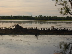
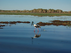
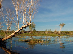
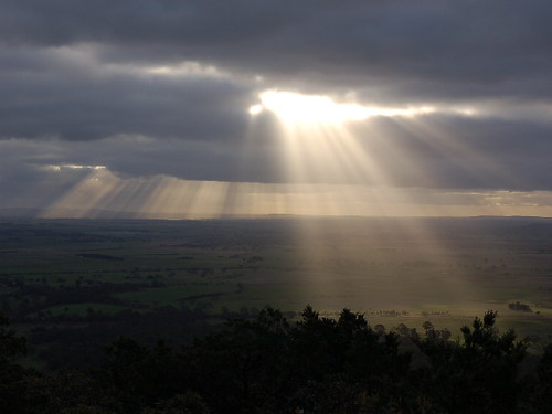
One interesting aspect of life in the Northern Territory is the relationship with water. The land is perpetually hot, with the sun beating down and humidity often above 70%. Since there are a nice coast line and a host of rivers, lakes, and billabongs, it seems like it would be nice and easy to head down to for a dip to remedy the boiling heat. Such is life that here in the Top End, there are two major deterents for jumping blindly into the nearest water hole, crocodiles and box jellyfish.

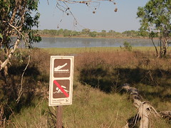
The box jelly inhabits the coastal ocean during most of the year, necessitating a safety suit or a large net to keep the buggers out. Affectionately known as "stingers," these nasty guys can deliver fatal stings to adults. That rules out the ocean for us. How about those rivers and billabongs? Let's talk croc now (although saltwater crocs live in the ocean too). There are two types of croc around these parts, saltwater and freshwater. Salties are the stuff of horror movies, growing to be over 15 ft long and attacking boats. Freshies are considered harmless since smaller and only eat fish. The rules of thumb for swimming are: 1. If you see a croc sign, don't go in. 2. If you don't, be scared out of your mind and go in at your own risk. With these rules in mind, let's journey into the waterholes around the Top End.

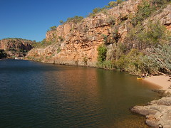
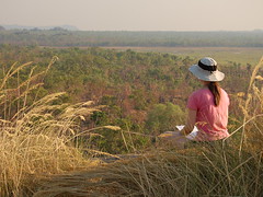
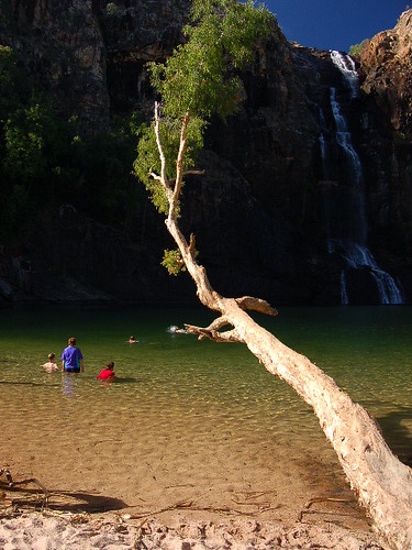
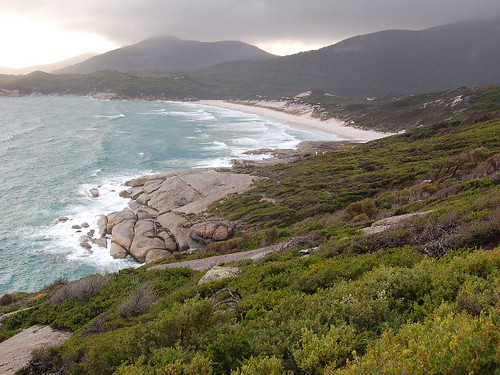
Nitmiluk National Park is the home of the Katherine River as it winds its way gently through a series of 13 gorges before heading to the coast. As an added bonus, an additional waterfall is found within the park borders.

Upper pools of Edith Falls


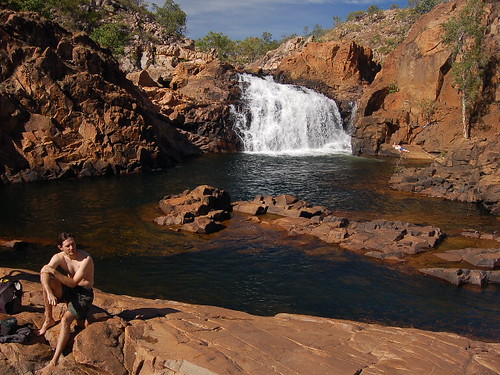
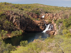
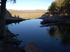
After pushing through a horde of 12-15 year old American tour groups, we made our way to look at Edith Falls. The plunge pool is a popular swimming spot with crystal clear water and a nice 50 ft fall. Rule 1 was not in effect, but there was a notice for freshies in the area. Although tempted to enter, we walked around above the fall and were rewarded with a wonderful pool that was almost guaranteed to be croc-free (as they would have to climb the waterfall to reach it). The pool was great, with its own recirculating current that brought you back to the waterfall.

Upper pools of Edith Falls Katherine Gorge


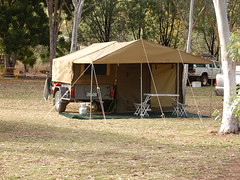
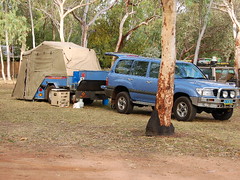
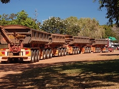
Our next stop was at the Katherine Gorge portion of the park. Here we were introduced into Aussie style camping. The thing to do here is get a beefy trailer behind your 4WD and tackle the outback. Some of the trailers were pretty interesting, folding out to reveal all kinds of canvas construction not thought possible. Usually these contraptions were accompanied by bbq apparatus of some sort. We felt left out with our rental sedan.

Camping Aussie Style Camping Aussie Style


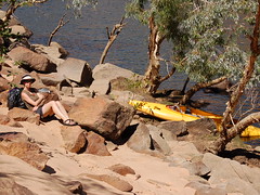
Our main activity while in Katherine Gorge was river kayaking. We were assured there were only freshies in the river, so it was ok to go. After no instruction or safety talk, we were let lose on the river. Our only instructions: portage over the rapids (both ways), and keep life jackets on at all times. Fair enough. We began by heading upstream. Eventually we reached the end of the first gorge denoted by the first rapid section. These are modest rapids (2 rating) with a span of about 20 ft or so. We jump out of the boat and begin the portage process. It takes 30 minutes of tugging with the 3 ft of bowline provided to get the boat into the second gorge, including some interesting moments walking more or less straight up three successive rapids. We accomplished this once more before entering the third gorge an hour later. With our victory came a nice lunch spot.

Kayaking on the Gorge Black Whip Snake


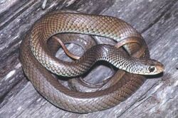
On the ride back things got a little more interesting. Looking around meekly, we didn't see any reason not to ride the boat down the rapids and save ourselves the effort. So begins the life of crime. The first rapids were successfully negotiated with a smirk. Buoyed by our success, we shot through the first set of rapids into the next canyon. At the third set, we decided to play conservative and walk the boat around an ominous looking rock. Spying a nice walking path, we lifted the boat and proceeded to walk. Apparently this set of alarms everywhere, as rangers descended on us and demanded we place the boat in the water immediately. It seems, given the choice, it was more dangerous for us to carry the boat on land than walk downstream through rapids towing a boat. To show our displeasure (as you can tell, I'm still angry about this one), we jumped in and rode the boat through the last rapids in full ranger view. Final kayaking note, didn't see a single croc. Other tidbit is Karen found a Black Whip Snake rushing between her boots during a walk, about 50 ft from the car. Yeah, it's poisonous.

I like termites! Magnetic Termite Mound


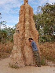
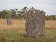
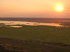
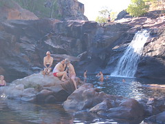
Our tour of popular swimming locations took us to Litchfield National Park, also home of the magnetic termites. These clever little guys build large, but thin, mounds to obtain the most stable temperature. Typically the mounds fall along nearly north/south orientation to catch the most sun. Curiously, the ability to do this clever bit of engineering is genetic with failure resulting in loss of the entire colony (has Boeing tried this approach yet?). Since there are no native Aussie grazing animals, termite mounds fit the bill. They dot the countryside in the way that cows do in a lot of other countries. The cathedral mounds are pretty impressive too. The tallest can be over 15 ft high. Along the way, we stopped at a couple of nice swimming spots where we just had to cool off.

Freshie


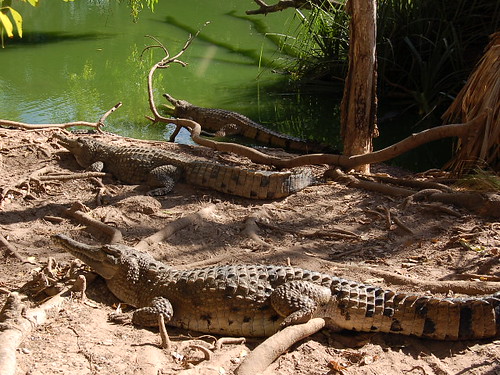
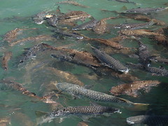
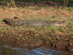
Finally, we decided to stop at a croc farm on the way back to Darwin to see just what these harmless freshies looked like. Take a look at the photo! Some were about 10 ft long, and all of them had those enormous teeth. We swam in rivers that had these guys present! Yikes.

With no real mishaps, we prepare to move on to the last stage of our adventure in Oz. Off to the reef and islands before heading home. While we loved our life for the past 6 months, it will be good to get home.

Kakadoodle-Du

(karen)
We're soaking up the sweet sunshine at last now that we've arrive at Australia's Top End in the Northern Territory. We flew from chilly Melbourne to sweltering Darwin, swapping long underwear and jackets for shorts and tank tops. Ah, this is my kind of winter! This is the Australian version of New Yorkers riding out the cold weather on a beach in Florida, crocs, snakes and all.

Darwin's Fannie Beach

Darwin is not a huge city despite being the capitol of the Northern Territory. We found little to do in the way of tourist diversions but did enjoy an hour feeding fish at a protected cove. For only $8 (ouch) you can toss slices of white bread into the water and watch the ensuing feeding frenzy. We actually did have a fun time, but not as much fun as the kids on field trip who were beside themselves with glee.

Feeding the fish at Aquascene Feeding the fish at Aquascene

The real allure of the Top End is the magnificent national parks that showcase the unique ecology of this region. The highlight was Kakadu, the first stop on our itinerary. Aboriginal people have inhabited this area for over 40,000 years. That is a length of time that I can't even begin to grasp. Both man and environment have grown and evolved together through many of mother Earth's changes, from the time of mega-fauna marsupials, to ice ages when the ocean levels were much lower, and at last to modern day Australia. In recent times a complex floodplain ecosystem has developed based on the monsoon wet and dry seasons. The Aboriginal people live in balance with their homeland, knowing when are the proper times to hunt certain animals, as well as lighting fires in the early dry season to "clean up" the floodplains. The plants here have come to depend on the seasonal fires; each year over 50% of the land is burned. This encourages new growth, makes hunting easier, and prevents large scale bush fires in the late dry season when the grasses are over dry and lightning storms take over.

 A perfect lilly in the marsh Wading birds on the flood plain

We are visiting the area in the early dry season, the season of bush fires, when the humidity is lower and the temperatures are more comfortable. The dry season is a very popular time to visit because not only has the massive flooding abated but this is when migratory birds flock to the billabongs to get fat on grasses and fish. If you remember the news from a few months ago, there was a late season cyclone (hurricane) that caused massive flooding in the region. When I say massive I mean the water depth on the floodplain was about 9 meters (~27 feet)! While that is normal for the Top End, it meant that many of the billabong trails that are usually open by now were still closed. It was a little frustrating to not explore as much as we would have liked, but still we found plenty to see.

You couldn't pay me to go swimming here An 82-wheeler road train

Kakadu is a World Heritage Site both for both ecological and cultural factors, a very rare distinction. There are over 5,000 rock art sites but only three are available for tourists to view. Most of the sites are within the Aboriginal owned territory called Arnhem. The paintings we are allowed to see are considered children's stories, ones that people ignorant of the culture are unlikley to misinterpret. I was blown away by the beauty of these paintings compared to the ones we saw down south at the Grampions. There are paintings on top of paintings that for thousands of years have recorded significant events and the fruits of hunting efforts, ensuring that the land will be prosperous for years to come.

We had a fantastic ranger guide us through some of the Aboriginal legends about such things as Lightning Man and the origin of Ginga, the saltwater crocodile. He also explained about the complexities of the societies like skin-names, and the laws that govern the roles within the clan.
Rock Art


Bush Tucker


Namarrgon (Lightning Man) and Namarmdjoing


We stayed at the rock art site of Ubirr to watch the sunset over the floodplain from a lookout on top of the sandstone escarpment. From up high we had breathtaking views of the vast floodplain surrounded by savannah and patches of monsoon rainforest. Small termite mounds dotted the landscape and wallabies darted around in the cool air of the evening. The thick smoke of the bush fires caused the sun to glow a brilliant magenta as it sank to the horizon.

Watching the world from Ubirr Lookout Sunset on the floodplain from Ubirr Lookout

One of the highlights of our trip was taking a guided dawn cruise down the Yellow Water River. As the sun rose the wetland animals came to life. Wading birds walked through the shallow waters looking for small fish, like the magnificent jabiru stork. We saw all kinds of other birds including whistling ducks, ibis, night herons, and the magestic white breasted sea eagle. Not to be outdone by the birds we also saw plenty of saltwater crocs casually resting at the surface like bumpy logs. At the end of our cruise we even spotted a large croc sunning himself on the bank, eyes closed and mouth open to regulate his temperature.

Whistling ducks crowd the mud flat A Jabiru hunts for fish
Cruising the Yellow River Ol' Salty


Gunlom Falls, Kakadu

For our final evening in the park we decided to camp at the stunning Gunlom Falls. It was a bumpy 37km dirt road in to the falls that left everything in our car covered in a fine layer of red powder, but it was worth it once we got to take a dip in the refreshing plunge pool.

A little bit of paradise at Gunlom upper rock pools Morning overlook from the top of Gunlom Falls

We took a small hike to the top of the falls where there were more rock pool to swim in. The water was clear and warm and it felt like a little slice of outback heaven. I guess when the oceans and billabongs are crawling with crocs, these plunge pools are the best safe swimming around! I'd highly recommend a trip to Kakadu if you find yourself in Australia some day.

Tuesday, June 20, 2006

Munching Through Melbourne

(steve)

Here we are in Melbourne, the city of food and art according to Lonely Planet. We arrived in town to eat, and eat well. Melbourne is a port city on southern coast where the Yarra River meets the sea. With nearby gold strikes in the mid 1800's, Melbourne became an overnight sensation filled with immigrants from China, Greece, and Italy. The blending of these different cultures resulted in a widely diverse city. All three cultures contribute to create a sophisticated feel to the city, from the architecture and fashion to the cuisine. Certainly, Melbourne deliberately moved at a slower pace compared with Sydney. It was fun to stroll through the secluded pedestrian lanes and sit in small cafes.

Melbourne Yarra Riverfront


Luckily for us, Chinese, Greek, and Italian cultures bring along some of our favorite cuisine. Our gastronomic stay in Melbourne was filled with a wide range of tasty treats from a variety of locations. Two notable spot were Stalactites (Greek) and Cafe Segovia (Modern Aussie) that particularly pleased. We also visited Max Brenners to sample their range of fine melted chocolate concoctions to round out the gluttony.

The centerpiece of our visit was definitely the Good Food and Wine Festival. Held in the Melbourne Convention Centre, the event brought together a wide range of food products to sample. Karen had read about the event while we were in Sydney, causing us to rearrange the schedule specifically to fit it in. Some examples of the products include everything from gourmet yoghurt to olive oils and also a wine and beer tasting area. To our surprise, a friend of ours from Brisbane (Tam, from the West Coast Wilderness team in New Zealand) was going to be in the city at the same time and wanted to meet us there. Armed with our wine glasses, the three of us roamed the floor for an afternoon and had a great time. During the show, a series of celebrity chefs gave demonstrations in one corner of the event centre. They broadcast the demo on a big screen accompanied by glib comments. One other surprise came when we stumbled across the New Zealand Wine display. Inside were two wineries that we had visited previously. We chatted about the visit with the Kiwis and they were all impressed we would remember. It was also interesting to sample their wine again and note differences from our first impressions. The festival was fun, and we hope to attend more of them at home now too.

Good Food and Wine Festival Good Food and Wine Festival with Tam Good Food and Wine Festival Good Food and Wine Festival


The very next morning we walked down to Queen Victoria Market to join the Foodie Tour. Queen Victoria Market is the largest open air marked in the southern hemisphere. The market filled about 7 hectares, complete with over 30 butchers, a huge deli section, cafes, produce halls, and merchandise of all shapes and sizes. If you were looking for something, chances are it was there. Our tour of the market focused on the food aspects. We started with the meat hall, where the butchers catered to specific portions of the populace (Greek, Italian, etc.). Along the way we were instructed on the differences between male and female pork, specialty vs. volume butchers, and a load of other little tidbits that often go unappreciated with a stroll along the booths. Our journey through the deli section included a number of sample stops to stuff our faces. The booth owners/operators were usually really nice and answered all manner of questions. It must be so nice to have that huge repository of experience to tap into at will. We decided that the market was about the coolest shopping experience we've ever had, and that it's too bad we don't have anything quite like it back home.

Queen Victoria Market Queen Victoria Market Queen Victoria Market Queen Victoria Market

Would You Be My Prom Date?

(karen)
We capped off our outdoor adventures on the chilly south-east coast of Australia with a jaunt down to the lovely Wilson's Promontory, known locally as "the Prom". This is one of Australia's oldest national parks thanks to a handful of early naturalists who fought to preserve this lovely Victorian penninsula from commercial development.


We had a long drive in from Geelong, just west of Melbourne on the Great Ocean Road, so our first day was cut a bit short. Couple our late arrival with a winter sunset around 5:00 and we had little daylight to play with, but at least the local critters start getting active at dusk. The first thing we noticed as we pulled into the park is that there are beautiful yet perpetually moody storm couds that blanket the penninsula. Fortunately the dramatic clouds allowed for some breathtaking crepuscular rays.

Rays

We were eager to stretch our legs after being stuck inside the car for so long. (After the compact scenic beauty of New Zealand we are still trying to readjust our sense of scale; Australia is about the same size as the continental USA.) We started with the Lilly Pilly Gully Nature Walk, mostly because of our choices I thought it had the coolest name. The walk took us through some surprisingly diverse ecosystems, from heath scrub to paper bark eucalyptus and sheaoak forest, and even temperate rainforest within the gully. The skies were unstable and it poured rain on us but at least we were prepared with long underwear, boots, fleece jackets, rain jackets, gloves, and wolly hats. Honestly, who knew it would be so frigid down under? Certainly not what I was expecting.

Look Out Again! Look Out!

We started on another hike through wombat territory, however despite signs of burrows, scat, and deep scratches in the hillside we didn't see any animals. It was getting dark so we got back in the the car and drove out to a grassy field often frequented by wombats, emus, and kangaroos. The light rain and dark clouds coaxed the animals out and we were delighted to find them grazing across the field. It was too dark to take photos so you'll just have to be content with a couple of the posted warning signs we encountered.

Emu Tracks

The next day we came back to the park and walked out to an area called Millers Landing. We found ourselves on a small, private beach at low tide, lined with mangroves and muddy flats. After a bit of exploration we came across fresh kangaroos tracks in the sand, but I was most impressed with the emu footprints in a muddy patch. The mud perfectly preserved the pebbly texture of its foot and a large claw at the end of each toe, like some kind of modern day dinosaur.

Squeaky Beach

Later in the day we drove on to the Tidal River area and went on a hike to Squeaky Beach, so named for the white silica sand that squeaks when you walk across it. It was too wet from the constant rain to do much squeaking, but I brought back a sample in a film canister to share with my science-buff mom. The beach itself was dramatic with the storm frenzied waves and the black clouds. We watched as thin sheets of rain moved quickly across the surface of the sea, until suddenly the wind whipped up and it passed over our heads, then momentary sunshine as it continued on across the surrounding hillsides.

Cuttlefish Backbone

We were surprised to find the beach littered not with shells but with giant cuttlefish backbones. There were literally hundreds across the sand, most small, but some reaching from my elbow to fingertips. I would love to see the size of the actual cuttlefish that these come from.

Again we found no large marsupials while hiking but we did encounter numerous birds including galahs, magpies, the elusive (for us) black cockatoo, rainbow lorekeet, and flocks of noisy, cheeky crimson rosellas. These birds are like kea, the New Zealand parrot, in that they are very intelligent and have completely taken over the visitor center. We snapped this photo as he was inspecting out our car tires, probably looking for a tasty rubber snack.

Crimson Rosella


The Prom was good to us and I wish that we could have gotten the chance to look around in better weather because we could easily spend a week backpacking into some of the more remote areas of the park. I suppose that will just have to wait for our next trip.

Thursday, June 15, 2006

Fire and Water

(steve)

Fresh from our fleecing on Kangaroo Island, we embarked on a long drive stretch to get to the Melbourne area. Our route took us through a large expanse of farmland, complete with rolling hills and lots of cows. There are two attractions along the way to keep us entertained. First up, Grampians National Park.

We rolled into Hall's Gap after about 7 hours worth of drive and ferry time. We were good and ready to get out of the car. Especially for me, the last hour of drive was a little nervous, since it was completely dark at this point and there are loads of kangaroos that like to hang out right next to the road after sunset. As you drive around the countryside the freeways are littered with carcases of the poor beasties, making a roo strike all too real a danger.

Grampians Recovery Rock Art


The Grampians lie in a park about 150 km west of Melbourne, making them a popular weekend spot for locals escaping the city. To complicate matters for us, our arrival coincided with a public holiday, the Queen's b-day. After not having to deal much with crowds during the winter, there were a lot of cars and folks about the place. Luckily, we found a room in one of the local hostels. The next day was spent touring the park. This park tour was different from others in that the surrouding forest was recently burned in a fire (last January). It was very interesting to see the trees in recovery mode. For eucalpyts, the first step is to shoot out a load of leaves from the trunk of the tree itself. This made the forest look like a collection of stumps covered with moss. Much like sequoias, fire is necessary for the trees to complete the reproduction cycle, with the heat releasing new seeds. At the same time, the forest floor begins to recover with a new carpet of ferns that spring up. Overall, the forest doesn't look like it suffered too much damage. Compare this to the result of a fire around southern CA. The Grampians is also home to a number of Aboringinal rock art sites. We visited two of them for your viewing pleasure.

The Grotto London Bridge (Fallen)


The second attraction was the Great Ocean Road. This is a 300 km stretch of highway that runs along the coast from Warrnambool to Geelong known for gorgeous scenery and dramatic landscape. We began the drive with a stop at the beach in Warnambool, where we heard a pair of southern right whales had arrived to give birth. The town is fascinated with these creatures, building a viewing platform for easy access. We joined a host of locals and watched as the two rolled just outside the breakers, coming up for air every couple of minutes. Nature at work. With a warm fuzzy, we headed out on the road.

The Arch Twelve Apostles


The Great Ocean road runs along coastline carved from sandstone at a rate of 2 cm per year. This rapid erosion leaves lots of arches, caves, and pillars standing (temporarily) in the surf. Combined with turquoise water, the scene was beautiful to behold. We lingered at colorfully named spots like Bay of Martyrs and the Twelve Apostles. This coast is also infamous for shipwrecks, hence the reverential names. Unfortunately for us, rain showers lingered with us for the day too. The drive was longer than we expected, but worth the effort.